Chapter 4
Modern Resource Management
By Eblal Zakzok
Despite the current political instability in the Middle East, it is still important for riparian nations to track their water resources. Given current security concerns, access on the ground has been difficult at best. It is simply too dangerous for personnel to enter certain areas of Iraq and Syria to maintain vital water infrastructure and track resources. In this type of environment, technology has been deployed to help relevant water authorities track the two most vital sources of water in the region.
GIS stands for geographic information systems. GIS is a system of hardware, software, people, data and organizations that work together to collect, analyze and disseminate information about areas of the earth. They work in tandem to collect geographical and environmental information about various regions around the globe. Part of previous bilateral and trilateral agreements between the riparian states from the late 1990s onwards encouraged the sharing of such information, particularly pertaining to precipitation levels.
The following maps, charts and figures were developed by Professor Eblal Zakzok based on data gathered from GIS satellites, in addition to the available census data about the region. Making the spatial data available and possibly served on the internet using web-based GIS could enable researchers to undertake different scientific studies to increase knowledge and understanding of the region. The use of reliable spatial data and related contextual knowledge are of particular importance to decision makers.
With the information gathered by GIS, the respective water ministries of the region will be able to better track the flow of the rivers, amount of precipitation, evaporation loss and discharge. With this knowledge they can better coordinate between one another how to best preserve and utilize the Tigris and Euphrates rivers. Colleagues have been working across borders under the auspices of ETIC for some time, with considerable levels of success and willingness to cooperate.
Image credits
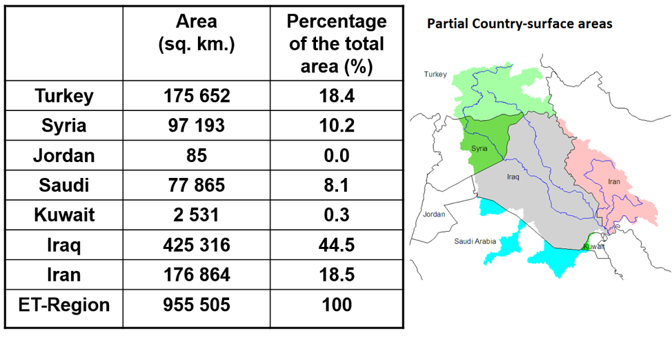
Image 17:
Surface Area of the Tigris Euphrates River Basin
Zakzok
C.C.2.0
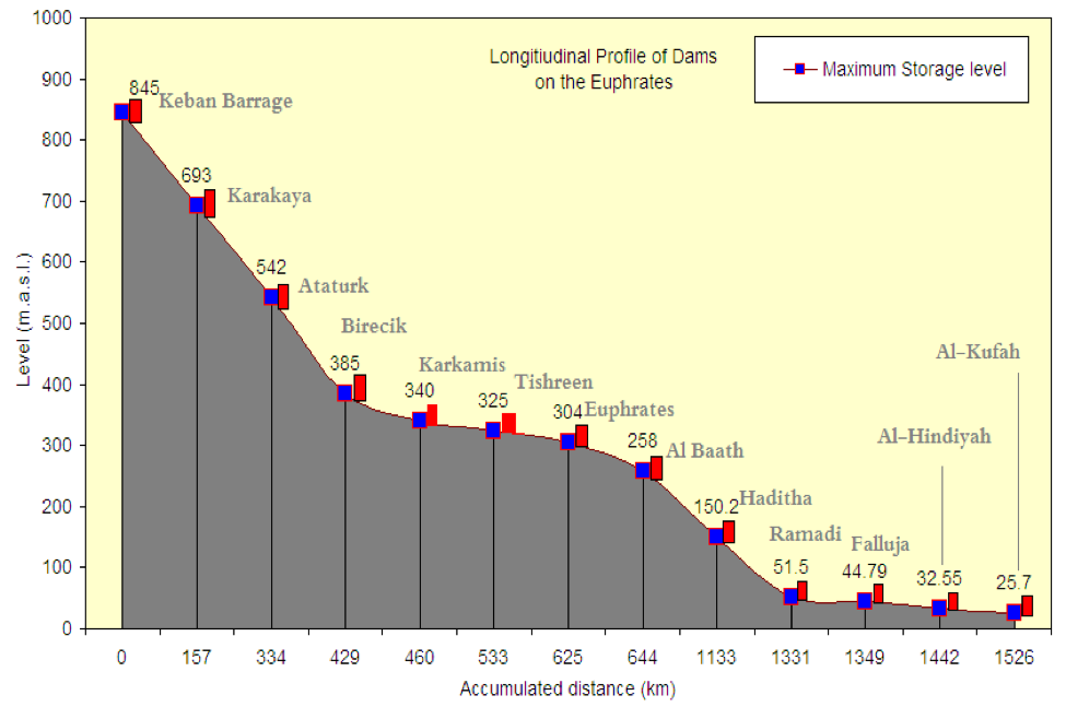
Image 18:
Profile of the Euphrates River and Its Dams
Zakzok
C.C.2.0

Feedback/Errata