Introduction
The Euphrates and Tigris River Basins
The Tigris and Euphrates rivers frame an area that is historically known as Mesopotamia, or “Land Between Two Rivers”. This region of the world has been home to many great civilizations throughout history, among them the Sumerians, Akkadians and Babylon being perhaps the most recognizable.In the Middle East, the Euphrates and Tigris may not be as large as the Nile, or other great rivers of the world, but they form the well-known “Fertile Crescent” which incubated what may have been the world’s earliest settled civilizations.
The ruins of many of these civilizations sit not too far from the banks of the Euphrates or the Tigris. Mosul, currently in the headlines a great deal, is near the Biblical city of Ninawa, situated in this area. Cultural and historical connections are numerous in the area, and also often make mention of the waterways, such as this Persian proverb:
“You toss charity in the Tigris, and God shall return it in the desert.”
– English translation, UT, Austin, Persian Online
The proverb can be translated roughly as “What goes around, comes around” (UT, Austin, Persian Online).
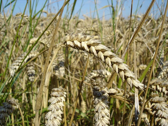
The kingdom of Akkad (2250 BCE), Abraham’s likely place of origin, made an indelible mark on the world, while at the same time many of the cities in the Euphrates Tigris region have been continuously settled for over 3000 years. These settlements have been successful based on the cultivation of wheat and other grain harvests which perform so well in the soil surrounding those rivers.
The Tigris and Euphrates rivers originate in the Taurus mountains of southeastern Turkey where they are fed with alpine snows, lakes and rains. From there they diverge and run south through the arid plains of Syria and Iraq before converging again and flowing into the Persian Gulf, with some contribution from tributaries originating in Iran. The Tigris runs for 1,850 kilometers, or 1,150 miles, whereas the Euphrates river runs for 2,800 kilometers, or 1,740 miles. The Tigris-Euphrates river basin covers an area of some 35,600 square kilometers, or 13,700 square miles, and comprises the riparian countries of Turkey, Syria, Iraq and Iran. “Riparian” simply means that they are situated on the banks of the aforementioned rivers.
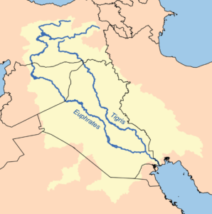
Each of the riparian nations provides a significant amount of water to the rivers, with Turkey being the dominant contributor. The Euphrates river has a mean annual discharge of nearly 32 Billion Cubic Meters (BCM), with 90% of this contribution coming from Turkey and 10% coming from Syria. The Tigris river has a mean annual discharge of nearly 52 BCM, with 51% of this contribution coming from Iraq, 40% from Turkey and 9% from Iran. The two rivers together have a combined annual discharge of nearly 84 BCM, of which Turkey provides 49 BCM, or 58%.
Usage of the Water
For the majority of their history, these two rivers have been used by the civilizations of the region and were relatively unregulated. This state of existence persisted for thousands of years. In recent decades, however, that has begun to change. In addition to irrigation, the rivers have been used increasingly for hydroelectric power and flood control by the governments of the countries through which the rivers flow. River usage can be divided into 6 main categories:
- Drinking water for the local population

2. Domestic use for the local population

3. Irrigation for agricultural development
4. Industrial applications

5. Recreation
6. National power generation
Increasing Tensions Related to Euphrates Tigris Usage
In the 1960s, the countries of Turkey, Syria and Iraq began to scale up their use of these rivers as they commenced modernizing water development projects. Initially, most of these projects aimed to regulate flooding, which occurs frequently for the Tigris and Euphrates. The projects soon began to focus increasingly on hydropower and drinking water initiatives, however, as the riparian nations began to develop their needs for water increased. Competition for water became an issue as Syria and Turkey built dams to protect against floods, and provide for droughts.
The competition intensified steadily. Flood protection projects in the riparian nations quickly became irrigation projects, and hydroelectric power plants were built. Demands increased further as these became primary sources of drinking water. The draw on the water is made more severe by the natural evaporation which occurs as the two rivers cross arid planes in Iraq and Syria, while the development of dams exacerbated the loss of water. While the countries had similar objectives: “security, provision of water supply and sanitation; food and energy (hydropower) ” (Kibaroglu,2016), they conducted their reforms nationalistically, consolidating resources for their own populations.
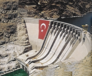
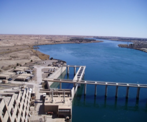
Tension turned to aggression as each state took a more nationalistic direction, in the form of Ba’athist party centrism in the Syrian and Iraqi Ba’athist regimes, in addition to Turkish development projects focusing on its southeast region. Multiple dams were built from the mid-1960s through the 1970s. Among the more notable of these dams were the Keban and Taqba dams in Turkey and Syria, respectively, in the mid-1960s and the Karakaya and Haditha dams built in Turkey and Iraq, respectively, in the mid to late-1970s.
とある白い猫, 23 September 2005, C.C.0, Wikimedia Commons
The Ba’athist governments in Syria and Iraq began to focus on agricultural development, land reform and large-scale irrigation projects, all of which required large quantities of water. In Turkey, the government launched the Southeast Anatolia Project, or GAP by its Turkish acronym. This controversial project saw the creation of dozens of dams meant to prevent flooding, provide hydropower, irrigation and drinking water to improve economic situation in the southeast of the country. Syria and Iraq both claimed the Turkish government restricted the flow of the Tigris and Euphrates in order to meet its own domestic needs.
The primary issue was that none of these projects were performed with official coordination with one another, or with acknowledgment of cross-border water rights. It was inevitable that these cross-purposes would eventually lead to friction between the riparian states. On one occasion a conflict over the Euphrates River nearly became a pretext for war between Syria and Iraq. Relations between Turkey and Iraq concerning the rivers have been marked by harsh rhetoric on both sides, but both countries continue to cooperate on issues concerning the river. Syrian-Turkish relations related to the Euphrates remained tense as both saw water security as a national security issue.
Amidst these political tensions, however, cooperation was required in order for the riparian nations to be able to manage the two rivers. Out of necessity, water officials in all three countries began to independently reach out to one another as early as 1964 to coordinate projects and negotiate technical assistance despite less-than-cordial government relations. Between 1965 and 1974, the three countries’ water authorities conducted Joint Technical Committee meetings on an ad hoc basis in order to address the needs of each country.
Despite these early and promising signs of cooperation, problems continued to persist, however. Each riparian nation prioritized their own development projects over cooperative agreements. Turkey continued to build dams in the Taurus mountains. Iraq and Syria continued to develop extensive irrigation projects and hydropower plants. All of these projects continued to strain the Tigris and Euphrates rivers. These tense and unmoving positions eventually led to the suspension of the talks in the early 1990s.
It was in this atmosphere that professionals working on the ground, lower level government officials and concerned citizens began meeting to exchange knowledge, and address issues at a grassroots level. The Euphrates-Tigris Initiative for Cooperation (ETIC) formed out of this situation. ETIC is a group of academics and professionals who have worked on knowledge-sharing activities, and aspects of transnational cooperation between Turkey, Syria, Iraq and Iran in regard to water resource management. ETIC knowledge sharing activities have entailed collecting publicly available data, training government officials in each of the riparian nations, and bringing together experts from different professions to harmonize their knowledge and analyze data for the benefit of people in the Euphrates-Tigris region. Prior to our meeting this year (2016) in Columbus, the last meeting was held in 2012 in Istanbul.
Image Credits
Image 1
Wheat Up Close
Bluemoose
31 July 2005
CC BY-SA 3.0
Wikipedia
Image 2
Karacaöen Reservoir
Duesentrieb
17 November 2006
CC BY-SA 3.0
Wikimedia Commons
Image 3
Map of the Combined Tigris-Euphrates Drainage Basin
Karl Musser
13 September 2005
CC BY-SA 2.5
Wikipedia
Image 4
Glass Half-Full
Jenny Downing
11 May 2009
CC BY 2.0
Wikimedia Commons
Image 5
Mopping
Dave Crosby
Flickr
Image 6
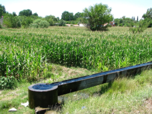
Irrigation Canal in Osmaniye, Turkey
Ozgurmulazimoglu
4 July 2012
CC BY-SA 3.0
Wikimedia Commons
Image 7
Piping
Bitjungle
7 April 2009
CC BY-SA 3.0
Wikimedia Commons
Image 8
River Rafting
Sumita Roy Dutta
26 August 2015
CC BY-SA 4.0
Wikimedia Commons
Image 9
Hartwell Dam
Albert Herring
9 July 2013
CC BY 2.0
Wikimedia Commons
Image 10
Karkaya dam-GAP
23 September 2005
Public Domain
Wikimedia Commons
Image 11
Haditha Dam in Iraq
Sergeant James McCauley
31 December 2004
Public Domain
Wikimedia Commons

Feedback/Errata