Stonehenge, UNKNOWN DESIGNER, AMESBURY, England, 2750-1500 BC
Plan and alignment diagram of Stonehenge
Part of the notoriety of Stonehenge is the mystery of the site, inspiring questions and theories. New technologies have facilitated recent discoveries, confirming or debunking previous myths and understandings. Located in southwest England, the developments at the site evolve over several thousand years from 2750 BC spanning through 1500 BC. This area is known for gently rolling topography since Roman times as an exporter of wool production. The site today is cared for by the English Heritage. In 2013 the visitor experience was enhanced significantly with the relocation of a new visitor center with a greater education of other important Neolithic monuments in proximity to Stonehenge (image 1).
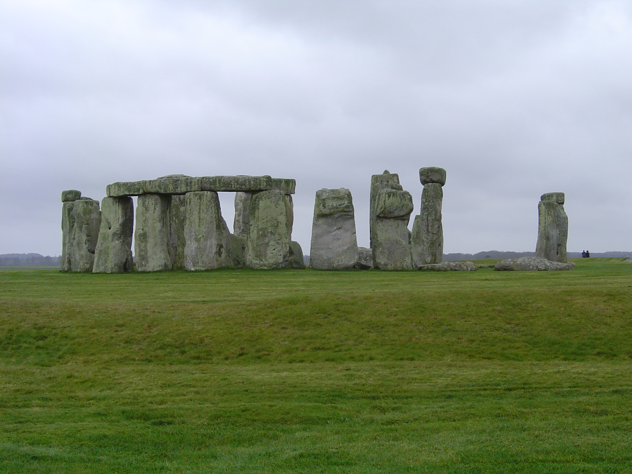
Image 1: Most complete view of Stonehenge
Important to note, the Neolithic people building during this time created many monuments in addition to Stonehenge. Other sites were made of different materials (Woodhenge) or scales enveloping entire towns (Avebury). The population was developing a network of over 900 monuments throughout England at the same time the Egyptians were building the Great Pyramids at Giza. This book focuses on the many architectural and landscape architectural constructions created by different peoples, each distinct and unique to each culture.
The purpose of Stonehenge had many meanings. It was a calendar, marking the sun’s path and celestial bodies in the sky. Today on the summer and winter solstice dates, there are large gatherings for either religious or celebratory purposes. It was a celebratory site, ritual space for ceremonies and observatory marking astronomical relationships. Though there have been bones found at the site, there are not yet clear answers as to these remains.
Stonehenge evolved as a series of different phases, this article focusing on only three phases. Further details and phases can be elaborated, but this text is an introductory exploration of these topics. In the first phase, a CHALK MOUND is constructed in the shape of a circle 320 feet in diameter, breaking in one place only in the northeast quadrant (image 2). Chalk is a mineral found in southwest England. The scale of the chalk mound (not larger circle) is about six feet wide and two feet tall and has remained throughout all developments of the site. The chalk mound today is covered with grass.
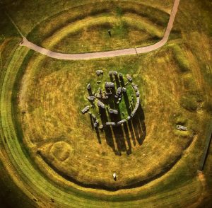
Image 2: Aerial view of Stonehenge with chalk mound
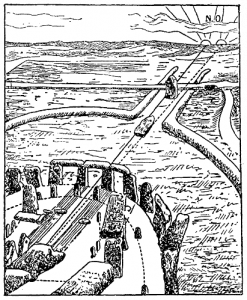
The importance of the break in the circle aligns with another important early element added to the site, the HEEL STONE (image 3). The Heel Stone is the one stone located outside the chalk mound, to the right of the break in the chalk mound circle. All other stones were added inside the chalk mound. The significance of the Heel Stone marks a connection to the sun. Standing in the center of the chalk mound circle on the summer solstice (the longest day of the year), the first rays of the sun rise to the left of the Heel Stone aligned with the opening in the chalk bank. The sophistication of the people building Stonehenge is that they not only understood but also marked these celestial relationships in stone, still present almost five thousand years later. England is rather far north and in the winter season, daylight is rather short. The sun was celebrated through this special alignment and marking. The Heel Stone is a distinctive stone with its specific markings and unique shape. The Heel Stone can be considered one of the many SARSENS at the site, a large upright stone.
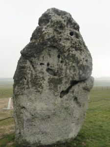
Image 3: View of the Heel Stone
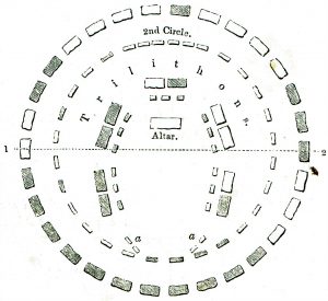
The next major phase of development is a pair of chalk mound extensions (35 feet wide) from the opening in the circle (image 4). The mounds proceeded straight until they curved toward the River Avon. Also in this phase was the addition of a double ring of BLUESTONES with an opening at the same location as the chalk bank. Bluestones are the smaller of the sarsens at the site, yet large in scale weighing five tons. The bluestones come from the Prescelly Mountains of Wales.
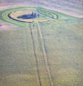
Image 4: Aerial view of chalk mound extensions
Later phases of development included many of the bluestones moving positions and the addition of the TRILITHONS (image 5). The trilithons are the largest of the SARSENS at the site weighing between 26-50 tons made of Marlborough stone. The trilithons were arranged in a horseshoe shape open to the break in the chalk mound inscribed within another ring of trilithons. Most of the trilithons are arranged in TRABEATION with two uprights and a lintel spanning above with no adhesive material connecting the stones, held purely by gravity (image 6). Trabeation, also known as POST AND LINTEL, is a construction system of vertical members (posts) working in compression and horizontal members (lintel) working in tension. This was a sophisticated construction system to be used almost five thousand years ago and required careful selection of lintels that could withstand the tension forces. Also, the question of how the Neolithic people raised and positioned the lintels twenty feet above the ground is yet unanswered. There are traces of construction methods including a small knob at the top of the posts. The lintels were cupped in reverse of the knob positions of the post to avoid slipping. Another important construction methodology was that part of the sarsens were below ground level to stabilize the stones on site.
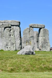
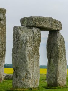
Image 5: Trabeation of Stones
These stones are mesmerizing. Looking closely at their details, one notices interesting marks and notches and vegetation growing on them. The site was not finished. One view of Stonehenge appears significantly more complete than most other views. It was a SUBLIME effort given their technological limitations. Sketching at the site will enable one to better understand the stones from larger organization to the details, the shadows they cast and the truly monumental scale.
The visitor center educates on many details of the site, including transportation system theories moving the stones to the site and in place. It is not yet confirmed, yet widely believed the stones were not transported across land instead by sea around the southwestern tip of England, then up the River Avon. For the last distance from the river to the site, transport would have likely involved a wood timber rolling system moving the stones to the site where Stonehenge exists today.
As noted to earlier, the new visitor center and experience was recently enhanced to better educate and create a more authentic experience. The road and parking lot within feet of the Heel Stone have been removed, a significant change to the site. Now one arrives at the visitor center, a thoughtfully designed sustainable building educating about not only Stonehenge, but the many monuments built in the area. The center has a room with 360 degree screens surrounding, showing Stonehenge throughout all seasons and the multiple phases of construction. A timeline places Stonehenge and the evolution of other great monuments around the world throughout human history. A trolley takes one to the stones that are not in sight from the center. Anticipation builds as one ascends the gentle slopes finally with the monument in site. It is impressive if one soaks in the magnitude of how the great monument was built and its meaning. And it places the evolution of architecture and landscape architecture into a larger perspective. It is built by people for a specific purpose, perhaps to gather, to celebrate beauty and meaning creating connections and belonging.
Media Attributions
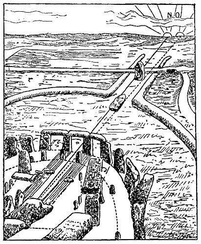
- Drawing of Stonehenge During the Equinox is licensed under a Public Domain license
- Plan Drawing of Stonehenge is licensed under a Public Domain license
- Elevation View of Stonehenge © Aimee Moore is licensed under a CC BY-NC (Attribution NonCommercial) license
- Aerial View of Stonehenge
- View of Heelstone at Stonehenge © Aimee Moore is licensed under a CC BY-NC (Attribution NonCommercial) license
- Aerial View of Stonehenge’s Chalk Bank © Aimee Moore
- Stonehenge Bluestone © Nick Amoscato is licensed under a CC BY (Attribution) license
- Detail View of Stonehenge © Mike Prince is licensed under a CC BY (Attribution) license
Circular shape around the stones at Stonehenge made from the mineral chalk. The chalk mound is broken in one area at the HEEL STONE.
the one stone outside of the chalk mound
a large upright stone
smaller of the SARSENS at Stonehenge, weighing up to 5 tons
Largest of the SARSENS at the site, weighing between 26-50 tons, made of Marlborough stone. These are the most common of stones associated with Stonehenge. Most of the trilithons are arranged in TRABEATION with two uprights and a lintel spanning above.
(these two vocabulary phrases mean the same) a construction system of vertical members (posts) working in compression and horizontal members (lintel) working in tension. Trabeation works better in specific materials (wood and steel) than stone because of the tension and spanning limits of the lintels.
inspiring a feeling of awe, could be by scale, function or effect.
