Energy
3.5 Ogallala Aquifer & Nebraskan SandHills Potentially Threatened by the Keystone XL Pipeline
Lee Seitz
The transcontinental Keystone XL Pipeline has the potential to contaminate a large Nebraskan water supply. What are the available alternatives to the pipeline that could prevent this possible contamination?
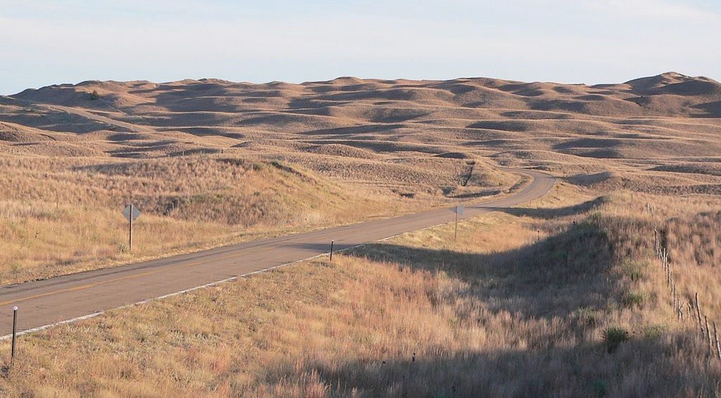
Photograph from Ammodramus, 2010. Public Domain.
The United States’ addiction to oil methodically follows a narrow-minded and myopic focus in the pursuit of the most advantageous route to obtaining “black gold”. The environment and national security are often victims in the procurement of oil by the United States. The Keystone XL Pipeline has great potential to be another chapter in oil production’s detrimental relationship toward nature. If completed, the pipeline will stretch 2,735 kilometers (1,700 miles) from the Tar Sands in Alberta, Canada to refineries in Houston, Texas.1 Some proposals for completing the pipeline put it directly over an important and fragile aquifer in Nebraska. This aquifer provides water for a large portion of the agriculturally rich Midwestern state.2 Routing the pipeline over the Nebraskan aquifer would endanger the water supply through its construction over the shallow groundwater and potential for oil leakage. In 2013, Nebraska Governor, Dave Heineman, approved a reroute around the aquifer that was proposed by the pipeline developer TransCanada.3 Searching for energy alternatives to oil is important for the survival of both the Ogallala Aquifer and a myriad of other vulnerable regions.
The expanse of the Ogallala Aquifer in Nebraska is contained within a greater water table called the High Plains Aquifer. The High Plains Aquifer stretches into Kansas, Oklahoma, Texas and small parts of South Dakota, Wyoming, Colorado, and New Mexico (Figure 2). The Ogallala Aquifer is named for resting atop of the Ogallala Formation of the Miocene Age, which is considered the principal geological unit of the aquifer. The Ogallala Formation consists of a heterogeneous sequence of clay, silt, sand, and gravel.4 Because this aquifer is located within the larger High Plains Aquifer, the possibility of contamination is especially significant. Additionally, depletion of the water level in the Ogallala Aquifer will increase the concentration of contaminants in the water table.12 The Nebraska portion of the Ogallala Aquifer represents an important “hydrologic unit” within the greater aquifer and contains some of the aquifer’s highest saturation levels.4 Covering 27 percent of the irrigated land in the U.S., the High Plains Aquifer provides 30 percent of the nation’s ground water used for irrigation while also supplying drinking water to 82 percent of people living within the aquifer’s boundary.2 Furthermore, the Nebraska Quaternary Deposits, the valley-fill alluvium, and the Ogallala Formation comprise the most widely used hydrogeological units in the aquifer, as measured by water use and percentage of irrigation area.4 Considering the expanse and use of this aquifer, any contamination would have a negative influence on not only the surrounding area but also the section of aquifer that rests atop of the Ogallala Formation, with the potential to compromise the greater High Plains Aquifer.

Courtesy of K. F. Dennehy, 2013.
The premise of an underground pipeline sounds containable and controllable against negative effects to the environment. However, two main problems arise when considering to build the pipeline over the Ogallala Aquifer: 1) construction of the pipeline could harm the aquifer, and 2) once the pipeline is completed, possible leakage creates an environmental concern. These problems are amplified in this region because of the Ogallala Aquifer and the Sandhills region of Nebraska, which is the region above the aquifer. The Sandhills region atop the Ogallala Aquifer is aptly named. Consisting of mainly coarse sand and gravel, the region’s soil composition is incredibly porous and acts as a giant sponge that quickly absorbs precipitation, which helps to recharge the Ogallala Aquifer.7 Soil composed of mainly sand and gravel is very fragile, and pipeline construction would disturb this sensitive, highly vulnerable, and agriculturally undeveloped land.5 Grassland covering 95% of the Sandhills region protect the area from wind erosion.7
The Tar Sands oil transported by the Keystone XL Pipeline makes potential leakage a grave concern for the Ogallala Aquifer and the Sandhills region. Tar Sands oil is more corrosive than standard oil which makes the Keystone XL pipeline more likely to rupture due to pipeline corrosion.6 Pipe cracking occurs from a combination of stress and corrosion.10 Pipeline failure will typically occur by a stress-oriented, hydrogen-induced cracking mechanism.11 Leakage into the aquifer is particularly troubling because oil will seep through the porous Sandhills Region as easily as rainwater.7
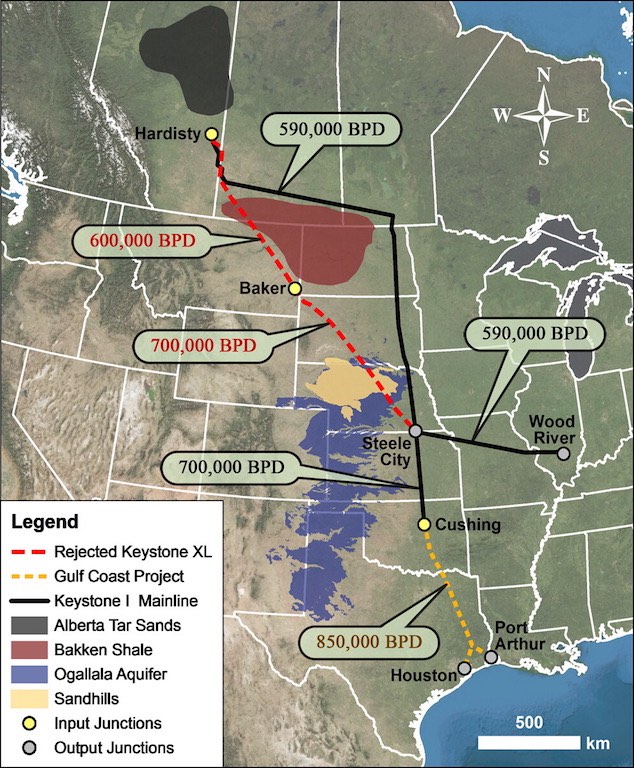
Estimated throughput volumes in Barrels Per Day (BPD).
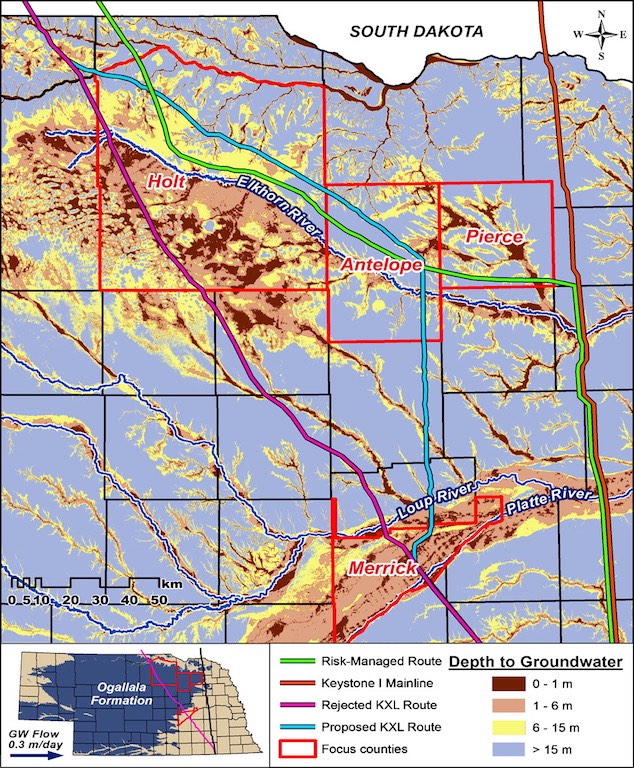
Used by permission from R. F. Spalding and A. J. Hirsh, 2012.
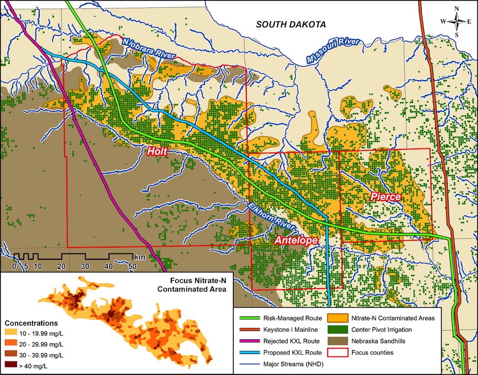
Used by permission from R. F. Spalding and A. J. Hirsh, 2012.
Used by permission from R. F. Spalding and A. J. Hirsh, 2012.
Advancements in renewable energy technology have the ability to eliminate the need for a transcontinental pipeline and can significantly reduce the U.S.’s dependence on oil. However, advancement of renewable energy is a gradual process and the economic pressure to transport Canadian oil to market is immediate. The next most popular alternative to the Keystone XL Pipeline is the use of rail transport (Figure 4). While the current pipeline proposal through the U.S. faces innumerable permitting obstacles, a pipeline that traverses either the east or west coat ofCanada would have similar permitting difficulties. Conversely, rail transport provides a quicker solution than the pipeline because rail does not require the same permits. Rail transport alternatives do have drawbacks. Transporting a barrel of oil would cost $15-$20 by rail, whereas pipeline transport costs only $7-$11 per barrel.8 Profit margins still exist for the oil companies because they are currently ordering train cars and constructing train terminals as a secondary option to the pipeline. Gary Doer, the Canadian ambassador to the US, stated quite bluntly that “oil is going to get to market,”8 either through a pipeline or by rail. Oil will be transported from Canada, North Dakota, and Montana to southern refineries. Transport via rail also negatively impacts the environment. Capitalist markets have put a high price on oil; and until other viable alternative energy sources exist, oil will be a powerful and environmentally damaging commodity.
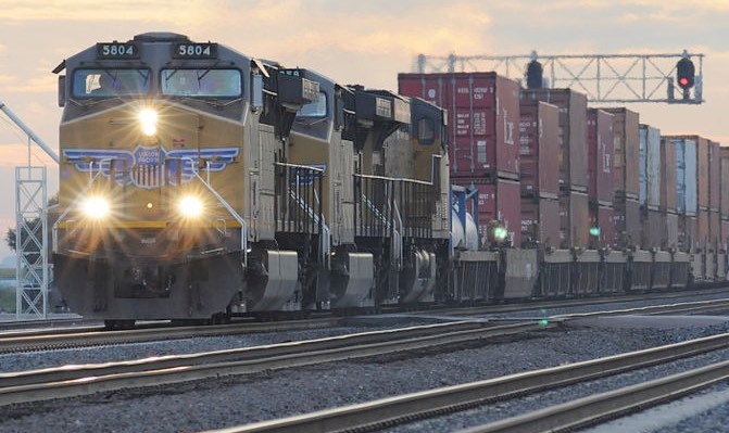
Photograph by Anonymous, 2010. Public Domain.
The most feasible alternative is to reroute the pipeline around the Ogallala Aquifer and Sandhills region. One reroute proposal is called the “Risked-Managed Route (RMR).” This route “avoids the sensitive, highly vulnerable, and agriculturally undeveloped land” (Figure 3).5 With the possibility of oil leakage the primary concern, the RMR traverses more agriculturally developed land. In more agriculturally developed land, the pipeline will be more accessible to vehicles for construction. Furthermore, the soil and irrigation wells in this agriculturally developed land have a history of spray irrigation. Oil is designed to drip down the pump shaft of irrigation wells to increase lubrication, but not all of this oil is caught by the well screen, and subsequently some oil leaks into the aquifer. The wells’ previous acclimation to oil has likely promoted the evolution of local bacteria to degrade the harmful property of petroleum hydrocarbons (PHC).5 In January 2013, Nebraska Governor, Dave Heineman, approved a route similar to the RMR proposal. The governor had previously advised President Obama and Secretary of State Clinton to reject the originally proposed route in the interests of the Nebraska Sandhills region and Ogallala Aquifer.9 Nebraska has faced passionate debate over the pipeline’s environmental impact, and proponents of the pipeline view approval in Nebraska as a major advancement toward the completion of the pipeline.
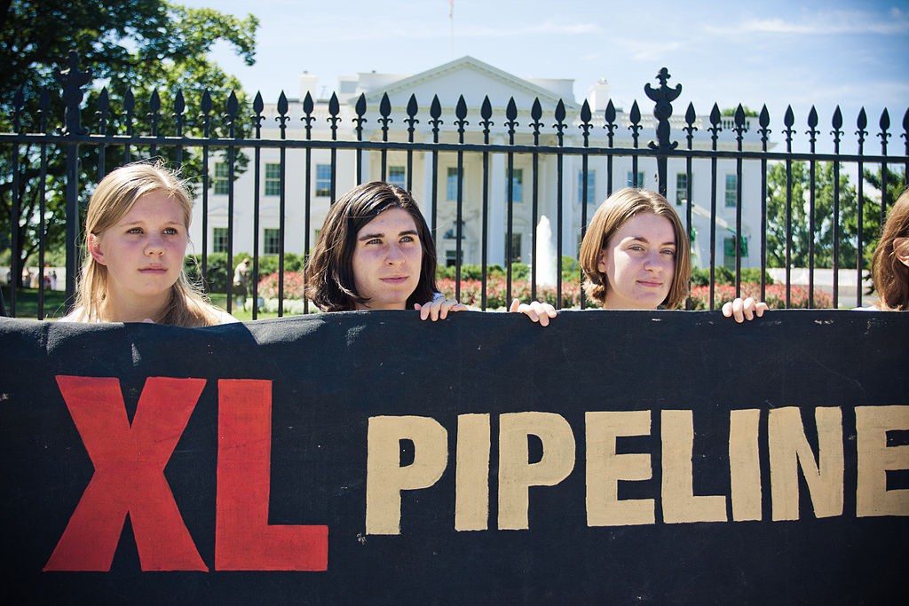
Photograph by Josh Lopez, 2011. CC BY 2.0.
Nebraska’s Ogallala Aquifer and Sandhills region are an integral part of the Midwest ecosystem. The soil composition of the Sandhills region enables it to supply water to the Ogallala Aquifer. Conversely, the benefits of quicker and more constant transport of oil through a pipeline are beneficial for national security by means of U.S. liberation from foreign oil. The reroute of the pipeline allows for the preservation of the Sandhills region and Ogallala Aquifer while also allowing for the transport of oil. This may be a necessary compromise between the competing interests of oil companies and environmental interests. Unfortunately, there will be pervasive environmental concerns regardless of the Keystone XL Pipeline’s final route.
References
- Bearden, T. (10 October 2011). Keystone Oil Pipeline Project Divides Nebraska Residents. PBS.org. Online. http://www.pbs.org/newshour/rundown/keystone-xl-pipeline-divides-nebraska-residents/
- Dennehy, K.F. (2013). High Plains Regional Ground-Water Study. USGS Fact Sheet: 091-00
- Schulte, G. (23 January 2013). Nebraska governor OKs rerouted Keystone XL pipeline. Denver Post. Online. http://www.denverpost.com/ci_22428969/nebraska-governor-oks-rerouted-keystone-xl-pipeline
- Dennehy, K.H., et al. (2002). The High Plains Aquifer, USA: groundwater development and sustainability, Geological Society, London, Special Publications, v.193
- Spalding R.F., & Hirsh, A.J. (2012). Risk-Managed Approach for Routing Petroleum Pipelines: Keystone XL Pipeline, Nebraska. Environmental Science Technology, 46:12754−12758
- Mark, J. (26 June 2012). Victory in the Pipeline. The Progressive. Pages 26-29.
- Parfomak, P.W., et al. (2013). Keystone XL pipeline project: Key issues. Washington, DC: Congressional Research Service.
- Mufson, S. & Eilperin, J. (2 March 2013). Rail Emerges as Alternative to Keystone Pipeline for Moving Canadian Oil. The Washington Post. Online.
- Broder, J.M. (2013 Jan. 13). Governor of Nebraska Backs Route for Pipeline. New York Times. Online. http://www.nytimes.com/2013/01/23/science/earth/keystone-pipeline-route-approved-by-nebraska-governor.html?_r=0
- Hasan, F., et al. (2006). Stress Corrosion failure of high-pressure gas pipeline. Science Direct. Engineering Failure Analysis 14 (2007) 801-809.
- Azevedo, C (2007). Failure analysis of a crude oil pipeline. Science Direct. Engineering Analysis 14 (2007) 978-994
- Edwards, J., et al. (2012). Building a Simple Genernal Model of Municipal Water Conservation Policy for Communities Overlying the Ogallala Aquifer. HeinOnline. 52 Natural Resources Journal, 135.
- Bureau of Oceans and International Environmental and Scientific Affairs (January 2014). Final Supplemental Environmental Impact Statement for the Keystone XL Project Executive Summary. U.S. Department of State.
- Ammodramus. (2010). Nebraska Sandhills in Hooker County, Nebraska, seen from Nebraska Highway 97 south of the Dismal River [Photograph]. Retrieved from Wikimedia Commons. Public Domain.
- Anonymous. (2010). Union Pacific Railroad’s Overland Route in Hershey, Nebraska. Retrieved from Wikimedia Commons. Public Domain.
- Lopez, Josh. (2011). Keystone XL Demonstration. [Photograph]. Retrieved from WikiCommons. CC BY 2.0.
